Site Owners
Pilots
Download our app below to start discovering new landing sites


Anyone with a Garmin screen will be familiar with:
Here we are flying to a point called MATCH. You can see various bits of navigation information:
I get these vectors easily muddled because the are not particularly intuitive. It’s frankly worse in French where track and course are both often translated as route.
Oh: I got carried away researching true and magnetic divergence – see bottom – really fascinating and bizarre.
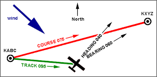
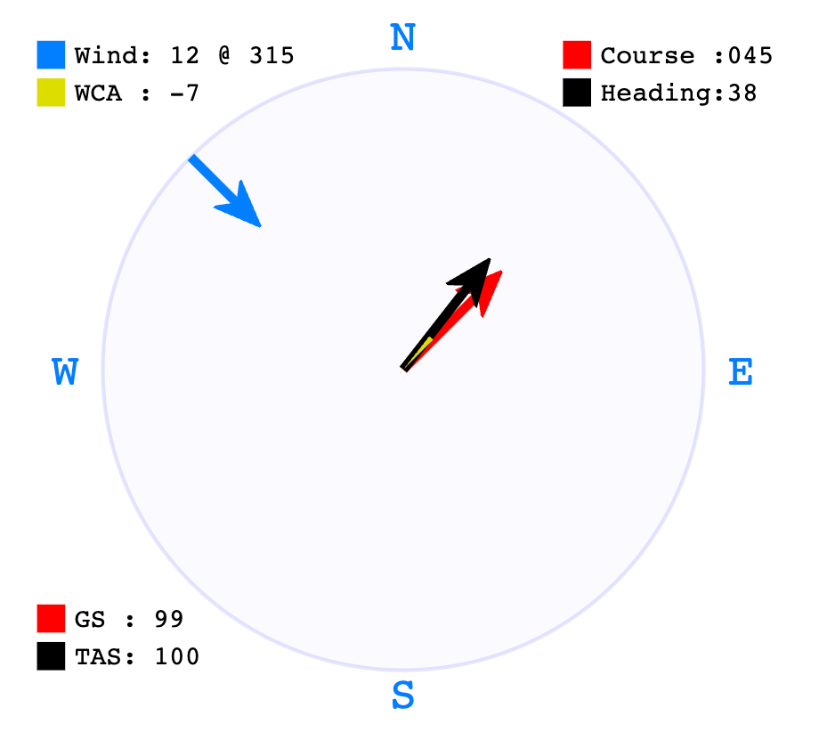
If I am flying home to KXYZ which is North East of me then I want to fly on a course of North East East (075). If there is a crosswind bearing from the left (a North Westerly) then I need to set my heading to a bit less than this as I will crab along pointing a little bit left of where my house is. I should end up tracking a line over ground that points exactly along the course. In the graphic above, I have decided to divert by 20 degrees for the first part of the flight and will now need to head 040 to get home which is now on a bearing of 060 instead of 075. Simple!
I penned this article because I was flying along in the R66 looking at the pesky pink diamond on the main TXi screen and wondering what it signified – I knew once but needed a reminder. This resulted in my more general revision of the four main navigation vectors that can be a bit confusing and which I describe further on.
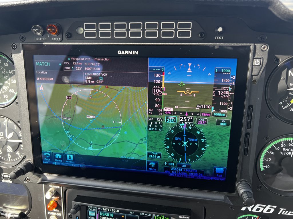
In the above screen, you can see that I am flying somewhere that is 29nm away at 067. Note: Ignore the blue heading bug (with the small indentation) in this example but if I was to switch on the HeliSAS HDG I would immediately turn to a heading of 063 as set by the blue heading bug. You can see that I have a crosswind of 21 knots so I am heading 056 to compensate: I’m crabbing along facing left of track. The G500H has not worked this out for me, I have to estimate the course adjustment of -11 degrees using my TAS of 110 knots and the crosswind component. I am actually 1 degree out of trim so, to be more precise, I should have headed 056 (not 057 as shown) because the correct adjustment is 11 degrees as shown here.
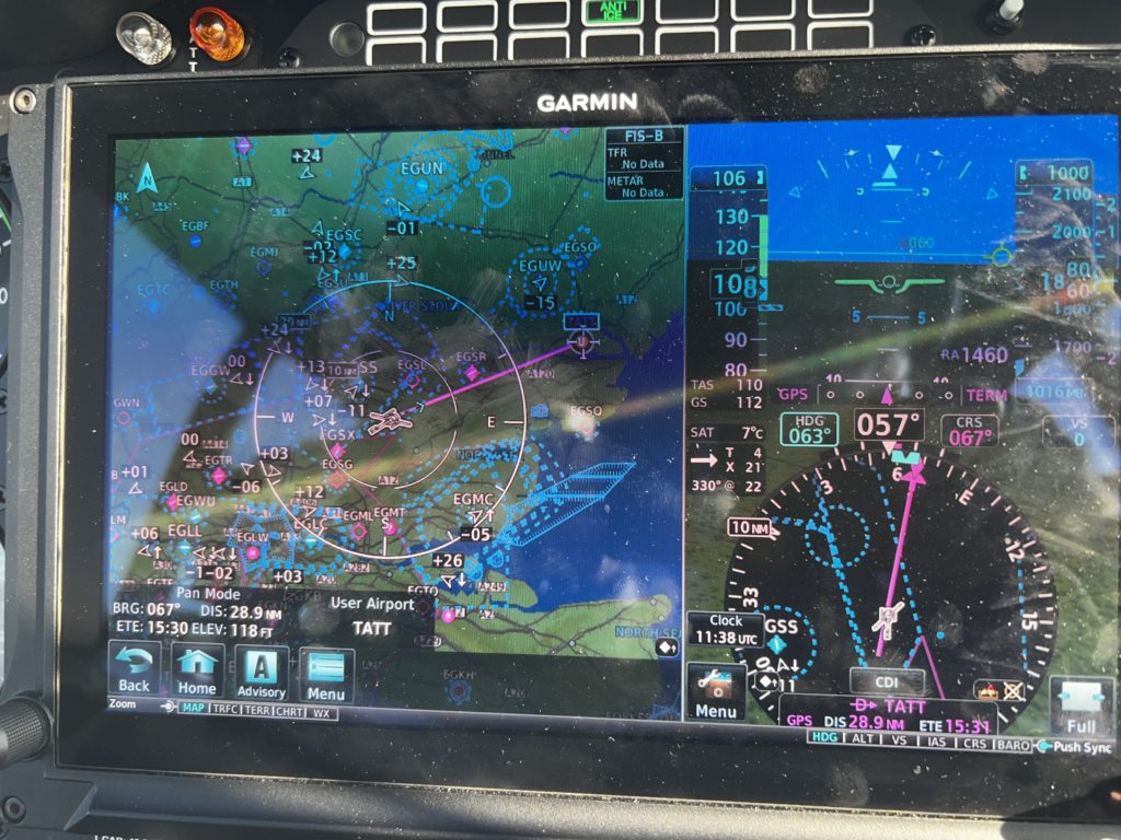
You can see on the G500H right hand screen the pink line which is the course and the compass rotates such that the track is always at the top (a small white triangle). If you look carefully you can see that pink diamond at the end of the pink course pointer. I steered right to get a better image here (I was also playing with the VOR display too):
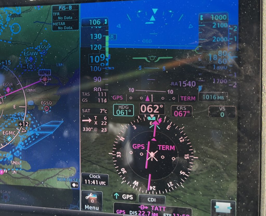
You can see I am heading 062 but the pink diamond is around 073 at the time I took this second photo. So what is this trying to signify? In fact, the diamond is the current track. So to be clear, I am off course now by 6 degrees to the right of the course and will not get home like this until I turn left again. My heading of 062 is somewhat irrelevant because I could be out of trim. If I am not out of trim, then my heading should be my track less 11 degrees or 062. Put another way, in the screen above, I am flying a heading of 062 which, given the 22 knot crosswind, gives me a track of 073. The pink course arrow is not a derived arrow, it is set by me by entering the position of my destination.
To recap the Garmin G500H TXi is showing me:
My heading: 062
My desired course to destination: 067 (calculated by the Garmin from my chosen waypoint)
My heading if I enable HeliSAS HDG: will become 061
My heading if I enable HeliSAS NAV: will move around but will be around 056 to get me on course of 067
My track over ground: the diamond or about 073
What happens to the vectors if I fly out of trim (I am slightly out of trim in the screenshot above)?
As Q from HQ would say “ooh my kidneys” when flying out of trim. You can see this from the trim indicator at the top of the display: I need to put in more left pedal to “push” the small white line to the right, turn the aircraft left a bit and lift the left side of the aircraft up so that I roll back to level. If I was to fly with no left pedal at all, the aircraft’s vertical stabiliser doesn’t provide quite enough yaw, even at 111 knots, so I would be pointing too far right and my heading would be higher than my track.
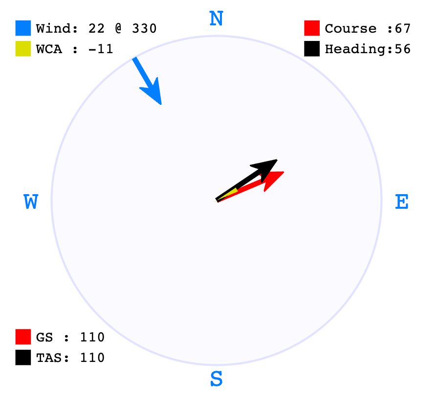
So if I am correctly tracking 067 along my 067 course to home, I actually have a choice of heading. My in-trim heading will need to be 056 to compensate for the crosswind. But I could choose to fly out-of-trim in which case I could set my heading to 057 and fly with too much right pedal.
Are you still with me? I could actually fly with a heading of 067 in which case I would be 11 degrees out of trim, but I would be in the correct track and get home. My aircraft would feel quite uncomfortable, lose a bit of speed, and rolling to the left.
Let me just interject here because a blocked pitot tube plays having with the indicators. This issue is actually very serious because it comes with a nasty confirmation bias, a human factor that is particularly dangerous.
In short, if you find you aways have a tail wind even when going into an airfield, you should check your pitot tube all the way along the tube. You may also end up flying at too fast an airspeed as it will read low. You may be fooled thinking that you can use the speed over ground (the GPS speed) but this doesn’t give an accurate airspeed if is windy. Please see the Helipaddy blog article on this problem.
Assuming a straight-line flight and steady wind, the course doesn’t change and I can look it up on a map before I take off. I think of it as the track over ground that I will need to follow. You have to enter it, or at least you have to enter a flight plan, as it’s not an output.
Bearing may be familiar when you are using VOR’s for navigation, god forbid, because VOR’s are reference points in space that are off your course. For objects outside the aircraft we usually use the clock face as a simplified bearing. For example, half way along my North Easterly journey home, I am off-course and my home is now on a bearing of 060.
Just to drive home the point here: if I am sitting on my helipad then I have a heading and things around me are on a bearing. But I have no course nor track.
Pretty similar to course in aviation because flights tend to be in straight lines obviously. Track is the line that the aircraft actually follows through the air, technically above the ground but usually depicted by navigation apps as being in the ground. Just to be pedantic, track is in 3d with up and down too.
It is impossible for track to differ from course in optimal straight line flying, regardless of crosswind and regardless of trim. But as soon as you avoid things, your track will deviate from the course.
Your track will be your heading + out of trim amount + crosswind component.
Which way my nose is pointing. If I am good at mental arithmetic, I can work out the best heading given my course and the wind’s bearing. Let’s say I have a 12 knot side wind from my left and the my home is on a course of 045. I need to set my heading to 038 to compensate – I calculated this using one of the plethora of “wind correction calculators”.
There is only really one source of north which is the compass. It is not possible to stand in a room and point to true north. Even outdoors, you would have to use a shadow during the day and the stars during the night. The G500H uses a database to be able to offer calculated true bearings as an optional setting. I actually don’t know what setting I have in mine.
Because the “authorities” are living in the dark ages, we still use magnetic north for stuff like runways. However true/magnetic directional divergence is a real-life issue.
In 2009, runway 1L-19R at the Fairbanks International Airport in Alaska was renamed 2L-20R as its heading increased above 15 degrees, requiring rounding up to 2L (20 degrees). It will probably have to be renamed again around 2033.
Today, the north pole of a compass needle points towards the ‘top’ of the Earth. This means that the top of the Earth must be acting as a South magnetic pole (unlike poles attract).
Earth’s magnetic field is created by turbulent currents in Earth’s molten metal outer core as they swirl around its solid iron inner core. Shifting currents mean the magnetic field is always moving. Which means magnetic north is always changing. And declinations around the world are always adjusting!
Changing temperatures and the liquid iron flowing around the core not only cause the strength of the magnetic field to change but also cause the poles to switch places. Today, the top of the Earth is a South pole but in the distant past it has been a North pole.
We can see this effect all around us. Streets and walls built to compass north a few centuries ago will now be off by several degrees.
Runways, which are named by their compass orientation to help pilots navigate them, periodically have to be renamed when the declination of that spot changes.


THANK YOU!